TotS Irish Adventure
August 4th and 5th. Days Five and Six.
A long time ago, in the northern part of Ireland, there lived a giant whose (Anglicised) name was Finn MacCool. He had heard tell of another giant, Benandonner, who lived in Scotland and Finn decided it would be good to fight him. In order to make that possible, Finn had to build a series of giant stepping stones across the sea between Ireland and Scotland. However, when he got close to Scotland and saw just how big Benandonner was, Finn got scared and ran back home. When he got there he asked his wife Oonagh to hide him. Oonagh dressed Finn up as a baby and put him into a giant cradle. When Benandonner arrived Oonagh told him that her husband was out but invited him to look at her baby. When the Scottish giant saw how big the baby was he imagined that the father of this child must be even bigger so he fled back along the Causeway, ripping up parts of it as he went, to stop Finn from following him.
This is the story, according to legend, behind the Giant’s Causeway, near Bushmills on the north coast of Northern Ireland. It is the most popular tourist site in Northern Ireland and has been so since 1693 when a bishop from Derry City and a Cambridge scholar published their ‘discovery’ of the site in a scholarly journal. Over the years visitors have included such luminaries as Sir Walter Scott (1814), Mark Twain (1882), Charles De Gaulle (1950) and Prince Charles, who stood upon the rocks in 1996. Today, we were going to make the most of our base at Moneyrea and visit that area for the day. This involved rising fairly early, travelling down into Belfast itself, then jumping on the M2 to head northwest to what is known as the Antrim Coast.
Much like the Great Ocean Road along the south of Victoria in Australia has many more scenic attractions than just the Twelve Apostles, so the Antrim Coast is much more than just the Giant’s Causeway. On another trip we will probably take the A2 route north of Belfast which runs out through Carrickfergus, Eden and Whitehead before heading along the coast through Larne, Carnlough, Glenariff and Cushendun, within sight of the Mull of Kintyre (yes, the one Paul MacCartney sang about) across the sea in Scotland. This would have also given us the opportunity to try out the rope bridge at Carrick-a-Rede, but given that we were not expecting the good weather to hold throughout the day, and both Brock and Meg had expressed a fair bit of uncertainty about wanting to go on the rope bridge, we decided to head straight for the Causeway.
Being a Monday morning, we expected the traffic into Belfast to be reasonably heavy, but hadn’t expected to have to stop at each set of traffic lights (the spawn of Satan) along the way. However, this gave us a chance to see a little more of Belfast itself and soon enough we were travelling fairly well (despite regular roadworks). We stopped at Ballymoney to get some fuel for Kylie and then headed due north through Dervock to the lovely village of Bushmills, on the River Bush which is, apparently, a great place for fishing for both salmon and trout.
Those of you who are into drinking whiskey might better know Bushmills as the name of a whiskey producer. King James I gave a licence in 1608 to the Old Bushmills Distillery making it the oldest legal whiskey distillery in the world. There is evidence that the production of ‘acqua vitae’ has been taking place here since the 13th century. You can do a tour and learn about the processes of mashing, fermentation, distillation, maturation and bottling, but given that Brock and Quinn are not of drinking age, we didn’t have any chocolate cake for Meg, and Wayne is not a fan of whiskey, the fact that the tour ends with a whiskey tasting meant that it wasn’t something we needed to do.
As we got closer to the Giant’s Causeway we were grateful that we had decided not to take too long over getting there. The queue for the carpark on the southern approach road that we were taking was well over a kilometre long. As well, there were two other, much smaller, roads which we could see coming in from the west and east which were also banked back quite a long way. While this gave us the opportunity to grow closer acquainted with some local cows, as well as the time to take in the view along the coastline heading northwest toward Portrush, we were grateful for every car that left the carpark, giving us the chance to move forward a few metres. That Meg and Wayne had the CD ‘Disco Is Not Dead’ playing at a good volume and were dancing along, even when pedestrians were walking past, made the boys even more pleased when we finally made the front of the queue.
When we reached the front and had paid £5 parking charge there was still a 10 minute wait for a space to become free. While we were waiting we heard the parking attendants get quite uptight that there were only 4 bus parking spaces available, but there were more than 5 coaches sitting back in the queue. Our advice to you, if you ever get the chance to come here (and it is well worth it) is to park back in Bushmills and catch the free bus up to the Causeway. This will give you a bit of a walk but will take a lot less time and save some money. Another option is to make sure that you get there as early in the day as possible, to try and avoid the heaviest traffic. Perhaps that it was a public holiday down south in the Republic of Ireland made our day particularly busy, but there are more than 500 000 visitors a year, so we don’t think it was an unusual experience.
It had been suggested to us that we walk down from the Visitors Centre and then catch the bus back up the hill, but as we walked through the buildings we saw the bus waiting and decided to get on board while we could (this cost another £3 for the four of us). Because of this we benefited on the way down the hill from a tour guide explaining the story of Finn MacCool, the geological reasons behind the existence of the Causeway, and pointing
  out some of the specific features. The National Trust had purchased the property back in 1961 and in 1986 the whole area was declared a World Heritage Site by UNESCO in recognition of its outstanding geological and other natural features. The 18 miles of coastline of which the Causeway is part has also been designated an Area of Outstanding Natural Beauty and apparently there are some species of bird and animal life which are only found here.
What you see when you get down to the Causeway itself is an astounding series of columns (apparently there are 40 000 but we didn’t count to check those figures), with their tops roughly evenly heighted, extending out into the ocean. The majority of the columns are 5 and six sided, so it looks like someone has taken millions of hexagonal and pentagonal rods and stuck them in the ground to form a pathway out into the ocean (no wonder they came up with the legend of Finn MacCool). In reality, the Causeway is basalt, solidified lava which has flowed down through a valley. As it has cooled, like mud when it gets dry, it has cracked and these cracks have extended all the way to the bottom of the flow, forming the columns.
When it was first found the Causeway was even more extensive than it is now (and it is very big) but during the Victorian era tourists were able to take home pieces of the basalt as souvenirs. We found it hard to imagine someone lugging away a giant basalt column, but apparently they were sliced across ways to make them more manageable. Quinn in particular enjoyed clambering up and over the stones. We also went down to the Giant’s Boot, another large lump of basalt which, viewed from the right angle, looks like a giant boot, and had our pictures taken on it.
In 1772 Sir Joseph Banks (who had earlier travelled with Captain Cook to Australia and catalogued the plant and animal life which was discovered there) discovered similar basalt columns in a place named Fingal’s Cave on the island of Staffa in Scotland. If you were able to walk underwater you would be able to follow the Causeway all the way because it is a continuous path. We had neither the time nor the resources to do that so we began the trek back up the path towards the Visitors Centre (and lunch).
  It wasn’t as steep as the walk the day before up Strabo, but it was much further. Among the other geological features we saw were; the Giant’s Chimney (a column stranded apart from the cliff, much like the apostles on the Great Ocean Road); the Giant’s Organ Pipes, (columns set into the side of the hill); the face of a Lion (the Giant’s organ pipes plus the area above it); and the Giant’s Camel (another basalt structure that looks a little like a camel).
We sat down for our pre-prepared lunch of sandwiches and drinks in a park area at the Visitors Centre at a table where some visitors from Dublin made room for us. They had travelled up for the long weekend but normally resided only a block away from Croke Park. When we commented on how busy we had found the traffic in their area they acknowledged that it made parking very difficult, hence the trip away this weekend. As they left
  we invited another group of tourists to share the table. It turned out that they were from Michigan and Illinois in the United States and were baseball fans. Wayne was very pleased to meet some fellow believers and they swapped updates on how various teams were doing. As they wandered off (they were on a coach tour and weren’t
  stopping for very long) they were heard to comment on the wonder of meeting an Australian, who lived in England, visiting Northern Ireland, who was a fan of a baseball team from Minnesota.
As we left the Giant’s Causeway we headed west along the coast road toward the nearby town of Portrush. Along the way this meant passing Dunluce Castle, or more precisely, the ruins of said Castle. It was built back in the 13th century on the cliffs overlooking Inishtrahull Sound, but might be considered to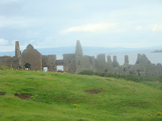 have been built too close to them. In 1639, during a storm, the kitchens of the castle, with the cooks and everything inside them, were swept into the sea. It makes for quite an eerie setting as a consequence and as we were driving the weather was starting to turn. Sadly, this was yet another reason not to play a round of Golf at the Royal Portrush Golf Course. It is a championship course ranked in the Top 4 of all of Ireland and only a short distance from the castle.
Portrush is Northern Ireland’s largest seaside resort town (think Coffs Harbour in NSW or Victor Harbour in South Australia) which flourished with the coming of the railway during the Victorian period. Being the height of summer, there were lots and lots of people there, but it was an interesting experience to drive a few laps through the town. The amusement parks and other family attractions seem to age as you travel back through. There is a Waterworld near the seafront but many of the facilities look old. Some of the buildings are amazing with their architecture, but the boys commented that it didn’t exactly look like a fun place to stay. Many of the teenagers standing in small groups outside billiard parlours and mini casinos in the town centre looked as if they would agree.
Coleraine was our final port of call for the day. We stopped to pick up some ingredients for dinner (Meg had volunteered to cook for everyone that night) which meant that we couldn’t stay very long. By now the unsettled weather that we had been watching come in had hit and it was starting to rain. It was a shame because the river running through the city, and the city itself, both looked lovely and we would have liked to spend more time there. Sadly, this is sometimes the misfortune of trying to cover two countries in a short space of time.
Traffic on the way back to Belfast flowed reasonably well until we reached the city itself. Despite our efforts to miss the majority of the traffic we had contrived to reach the inner suburbs just on 5 pm and the rush hour. By now we were starting to recognise features that we had seen before (such as the two large yellow structures which loomed over the docklands area of the city) and this made the final part of the trip much easier. Having already spent two nights there, Moneyrea was much simpler to find than it had been when we first arrived. When we got back we had missed Julie, however, and Zoe was not feeling hungry, so Meg cooked us a lovely dinner before we retired to another nights sleep.
All of the bad weather which we had seen coming the previous day was upon us by Tuesday morning which began quite cold and wet. Undaunted by the forbidding conditions we jumped back into Kylie to retread some of the ground we had covered on the day we first arrived in Northern Ireland but which we had not had time to see in much detail. This meant heading back south on the M1 and across the border back into the Republic where we were headed for a place called Carlingford. This is the namesake of the suburb in Sydney where Wayne spent most of his teenage years and we were all interested to see what it was like.
One of the things that we have discovered (and probably talked about before) that makes living in or near the area in which you are travelling interesting is that if you see a signpost that takes your fancy, you are able to be spontaneous and wander off in previously unforeseen directions. This is because the opportunity to return is much more immediate than if we had flown out from Australia for a holiday when time to see things
would be much more limited. This is exactly what happened today as we spotted a sign pointing to what was called ‘Bronte Homeland’. Meg is quite a fan of the Bronte sisters and those who know her well would know that when Brock was in utero he was expected to be a girl whose name would have been Bronte Mia. It was only when he emerged that his name changed rather hastily to Brock, however with the length his hair has now reached we are beginning to feel that Bronte might not have been such a bad choice. So off we detoured, determined to find how the Bronte Homeland could exist in Ireland, when the Bronte’s lived in England.
The Bronte Homeland drive began in Drumballyroney near where the Bronte sister’s father, Patrick, had been born in 1777. Consequently, our first stop was the old church there and a school where he had once taught. As it turned out his name had originally been Brunty and he changed the spelling when he moved to Haworth, Yorkshire, to further his education. Before leaving, he had first worked
  as a linen weaver before taking up school teaching at the Glascar school on the road between Rathfriland and Loughbrickland. Despite being seen as an ‘enlightened’ teacher who used different teaching methods (including rambles in the Mourne mountains) to bring out the best in his pupils, he was
  later dismissed because of a romantic attachment with one of his students. There is very little remaining of the cottage he was born in or some of the other landmarks in the area. However, what was very interesting was to see that graves from the late 19th century onward also bore the name Bronte, rather than Brunty. It seems that people trying to take on the fame of others because of a family name is not a recent phenomenon.
Trying to exit the Bronte Homeland was a much more difficult task than entering it had been. This is becoming quite a feature of our time in Ireland (see the entry on Day 2 of our travels regarding the Kennedy Homeland or on Day 3 when returning from Kilkenny). However, after wandering around the country lanes between Newcastle and Banbridge we eventually found ourselves back on the road headed toward Newry.
All morning the rain had been on and off, but as we crossed the border again south of Newry the air became filled with two distinct sounds. The first was the sound of quite large raindrops hitting the car as a storm broke upon us, the second was a cry of anguish from Brock because he had joined a different mobile phone provider to Wayne and Meg and his signal had failed (as it would do whenever we were in the Republic rather than Northern Ireland). Because Carlingford had been a place that Wayne, in particular, had wanted to visit, he offered to turn back because of the weather, however Meg staunchly insisted that we keep going. Similarly, Brock’s wails were turned aside with the comforting words, ‘it will only be a few hours, and then you and Amy will be back in instant contact again’.
According to the book ‘Carlingford Town: An Antiquarians Guide’ “the name Carlingford evokes three images: firstly, a rugged peninsula on the eastern seaboard of Ireland; secondly, a breaktaking sea-lough delving deep into the uplands of south Ulster; and thirdly, a quiet, venerable town in the northern part of the county of Louth.” This calls into question the practice by which names
  in Australia are chosen. When one thinks of Carlingford in Sydney one is much more likely to envisage a middle-class landlocked suburb focussed upon a medium sized Westfield Shopping Centre; what was once the largest Mormon temple in the southern hemisphere; or a public Secondary School where the school mascot, bizarrely, is Hagar the Horrible.
In reality, Carlingford in Ireland is a beautiful old Irish village where, because of its placement in relation to mountains and safe harbours, the industrialisation which ravaged the old buildings of many of its neighbours had not had the same impact. Consequently, there are numerous old castellated ruins which indicate some of the past the area has had. The most obvious of these, as you drive into the town, is the ruins of
  King John’s Castle, named for his visit to the area in 1210 but almost certainly built prior to that date. Not long after, in 1229, Hugh de Lacy granted the ‘Castle and Town of Carlingford’ to David, Baron of Naas, upon his marriage to his daughter, Matilda. By the middle of the 13th century Carlingford’s extensive sea trade meant that it was numbered
 among the ports of Ulster, along with Dundalk, Strangford, Carrickfergus and Coleraine. However, come the 16th and 17th centuries it went into a period of decline, being sacked around the Irish campaigns of Cromwell and burnt on Sir Phelim O’Neill’s orders in 1642. Even then, the harbour was used by William of Orange in his preparations prior to the Battle of the Boyne, but Carlingford never took off in the way other towns nearby did.
These days, Carlingford is still a fishing port, but because of the shallow depth of its harbour it cannot take a large commercial ship which limits its size. Instead, it is known for the oysters that grow in the Lough off its shore. As well, tourism plays a significant role here, with Carlingford being a base for people wishing to explore the Lough, the Mourne Mountains and the National Park which lies between it and Newry.
  The very old nature of so many of the buildings also makes it particularly interesting for people inclined towards history and architecture. We spoke to the lady serving in the Tourist Information Office who said the area was growing and we saw lots of new housing being built as well as a number of new looking hotels. Of course, the reason for the Viking mascot of its namesake is that the name Carlingford comes from Carlinn’s Fjord, the original Viking name for the area.
One of the things that we have noticed very particularly about Ireland is the enormous impact that faith has. Much as Meg and Wayne experienced in Mexico, in the Republic there are regular shrines by the side of the road and the churches and cathedrals are prominent features of the towns. In the north there is not so much evidence, although the prominence of the churches and the Union flags which fly outside many of the protestant ones are frequently visible. We mention this because, as we drove north of Carlingford toward Ballinteskin we came across a large shrine to Mary and St Bridget and because of Brock and Quinn’s Catholic background we stopped to have a look.
From here we drove north back over the border into Northern Ireland, much to Brock’s delight, and to the city of Armagh. Armagh is the least populated city in the whole of Ireland and was the “ecclesiastical capital” of Ireland. St Patrick is said to have established his principal church there and stipulated that only priests educated at Armagh could spread the gospel. The cemetery at St Patrick’s in Armagh also contains the grave of Brian Boru who became High King of Ireland in 1002, until his death in 1014, after having conquered the island during the 990s.
Our experience of Armagh was more influenced by some of its more recent history. During ‘the Troubles’, between 1975 and 1994, Armagh was the location of a number of bombings and executions carried out by members of both sides. This was the first city that we had spent any significant time in where the troubles had been so extensive and there was, we felt, a strange air about the place. That there were clear divisions was still obvious in the flags hung in different parts of the city and the decorations on the guttering of the roads. While we drove around the main streets in the centre of the city, both Meg and Wayne didn’t feel entirely comfortable there and our stay wasn’t very long.
This was a contrast with our next destination, Portadown, a little further up the road toward Belfast. Portadown has also had a violent past. The areas earliest settler’s were the ancient and powerful McCann family. The town was also the scene of an infamous massacre during the Irish Rebellion of 1641, when the Catholic insurgents killed around seventy of the Protestant townspeople on the bridge over the River Bann. During the troubles, Portadown was located in what was known as “the murder triangle” because of the large number of killings carried out by paramilitaries in the area. Even as late as 1997 a catholic civilian, Robert Hamill, was beaten up and killed by a group of 30 protestants in the centre of town. However, the feel within the town was nothing like that in Armagh.
A month or so earlier, Wayne and some of his students at the school had been discussing possible football tipping competitions and conversing about different teams in different countries around the world. Some of them decided that they would pick a team to support in every country of the world. In Northern Ireland he picked Portadown, so while Meg went shopping and the boys spent time in an internet café, Wayne went to
  a local sport store to see if he could find out more about the team. As it turned out, the new Portadown Football strip had arrived in the store that day, and the first game of the new season was to be played that evening. The owner of the store gave Wayne a reference to allow us to go up and tour the ground and sold him a brand new Portadown strip on the proviso that it wouldn’t be worn until the 18th (when it would be officially launched). In fact, everybody in the town was really helpful and friendly and it made a nice final stop before heading back to Moneyrea.
August 4th and 5th. Days Five and Six.
A long time ago, in the northern part of Ireland, there lived a giant whose (Anglicised) name was Finn MacCool. He had heard tell of another giant, Benandonner, who lived in Scotland and Finn decided it would be good to fight him. In order to make that possible, Finn had to build a series of giant stepping stones across the sea between Ireland and Scotland. However, when he got close to Scotland and saw just how big Benandonner was, Finn got scared and ran back home. When he got there he asked his wife Oonagh to hide him. Oonagh dressed Finn up as a baby and put him into a giant cradle. When Benandonner arrived Oonagh told him that her husband was out but invited him to look at her baby. When the Scottish giant saw how big the baby was he imagined that the father of this child must be even bigger so he fled back along the Causeway, ripping up parts of it as he went, to stop Finn from following him.
This is the story, according to legend, behind the Giant’s Causeway, near Bushmills on the north coast of Northern Ireland. It is the most popular tourist site in Northern Ireland and has been so since 1693 when a bishop from Derry City and a Cambridge scholar published their ‘discovery’ of the site in a scholarly journal. Over the years visitors have included such luminaries as Sir Walter Scott (1814), Mark Twain (1882), Charles De Gaulle (1950) and Prince Charles, who stood upon the rocks in 1996. Today, we were going to make the most of our base at Moneyrea and visit that area for the day. This involved rising fairly early, travelling down into Belfast itself, then jumping on the M2 to head northwest to what is known as the Antrim Coast.
Much like the Great Ocean Road along the south of Victoria in Australia has many more scenic attractions than just the Twelve Apostles, so the Antrim Coast is much more than just the Giant’s Causeway. On another trip we will probably take the A2 route north of Belfast which runs out through Carrickfergus, Eden and Whitehead before heading along the coast through Larne, Carnlough, Glenariff and Cushendun, within sight of the Mull of Kintyre (yes, the one Paul MacCartney sang about) across the sea in Scotland. This would have also given us the opportunity to try out the rope bridge at Carrick-a-Rede, but given that we were not expecting the good weather to hold throughout the day, and both Brock and Meg had expressed a fair bit of uncertainty about wanting to go on the rope bridge, we decided to head straight for the Causeway.
Being a Monday morning, we expected the traffic into Belfast to be reasonably heavy, but hadn’t expected to have to stop at each set of traffic lights (the spawn of Satan) along the way. However, this gave us a chance to see a little more of Belfast itself and soon enough we were travelling fairly well (despite regular roadworks). We stopped at Ballymoney to get some fuel for Kylie and then headed due north through Dervock to the lovely village of Bushmills, on the River Bush which is, apparently, a great place for fishing for both salmon and trout.
Those of you who are into drinking whiskey might better know Bushmills as the name of a whiskey producer. King James I gave a licence in 1608 to the Old Bushmills Distillery making it the oldest legal whiskey distillery in the world. There is evidence that the production of ‘acqua vitae’ has been taking place here since the 13th century. You can do a tour and learn about the processes of mashing, fermentation, distillation, maturation and bottling, but given that Brock and Quinn are not of drinking age, we didn’t have any chocolate cake for Meg, and Wayne is not a fan of whiskey, the fact that the tour ends with a whiskey tasting meant that it wasn’t something we needed to do.
As we got closer to the Giant’s Causeway we were grateful that we had
 decided not to take too long over getting there. The queue for the carpark on the southern approach road that we were taking was well over a kilometre long. As well, there were two other, much smaller, roads which we could see coming in from the west and east which were also banked back quite a long way. While this gave us the opportunity to grow closer acquainted with some local cows, as well as the time to take in the view along the coastline heading northwest toward Portrush, we were grateful for every car that left the carpark, giving us the chance to move forward a few metres. That Meg and Wayne had the CD ‘Disco Is Not Dead’ playing at a good volume and were dancing along, even when pedestrians were walking past, made the boys even more pleased when we finally made the front of the queue.
When we reached the front and had paid £5 parking charge there was still a 10 minute wait for a space to become free. While we were
 waiting we heard the parking attendants get quite uptight that there were only 4 bus parking spaces available, but there were more than 5 coaches sitting back in the queue. Our advice to you, if you ever get the chance to come here (and it is well worth it) is to park back in Bushmills and catch the free bus up to the Causeway. This will give you a bit of a walk but will take a lot less time and save some money. Another option is to make sure that you get there as early in the day as possible, to try and avoid the heaviest traffic. Perhaps that it was a public holiday down south in the Republic of Ireland made our day particularly busy, but there are more than 500 000 visitors a year, so we don’t think it was an unusual experience.
It had been suggested to us that we walk down from the Visitors Centre and
 then catch the bus back up the hill, but as we walked through the buildings we saw the bus waiting and decided to get on board while we could (this cost another £3 for the four of us). Because of this we benefited on the way down the hill from a tour guide explaining the story of Finn MacCool, the geological reasons behind the existence of the Causeway, and pointing
  out some of the specific features. The National Trust had purchased the property back in 1961 and in 1986 the whole area was declared a World Heritage Site by UNESCO in recognition of its outstanding geological and other natural features. The 18 miles of coastline of which the Causeway is part has also been designated an Area of Outstanding Natural Beauty and apparently there are some species of bird and animal life which are only found here.
What you see when you get down to the Causeway itself is an astounding
 series of columns (apparently there are 40 000 but we didn’t count to check those figures), with their tops roughly evenly heighted, extending out into the ocean. The majority of the columns are 5 and six sided, so it looks like someone has taken millions of hexagonal and pentagonal rods and stuck them in the ground to form a pathway out into the ocean (no wonder they came up with the legend of Finn MacCool). In reality, the Causeway is basalt, solidified lava which has flowed down through a valley. As it has cooled, like mud when it gets dry, it has cracked and these cracks have extended all the way to the bottom of the flow, forming the columns.
When it was first found the Causeway was even more extensive than it is now (and it is very big) but during the Victorian era tourists
 were able to take home pieces of the basalt as souvenirs. We found it hard to imagine someone lugging away a giant basalt column, but apparently they were sliced across ways to make them more manageable. Quinn in particular enjoyed clambering up and over the stones. We also went down to the Giant’s Boot, another large lump of basalt which, viewed from the right angle, looks like a giant boot, and had our pictures taken on it.
In 1772 Sir Joseph Banks (who had earlier travelled with Captain Cook to
 Australia and catalogued the plant and animal life which was discovered there) discovered similar basalt columns in a place named Fingal’s Cave on the island of Staffa in Scotland. If you were able to walk underwater you would be able to follow the Causeway all the way because it is a continuous path. We had neither the time nor the resources to do that so we began the trek back up the path towards the Visitors Centre (and lunch).
  It wasn’t as steep as the walk the day before up Strabo, but it was much further. Among the other geological features we saw were; the Giant’s Chimney (a column stranded apart from the cliff, much like the apostles on the Great Ocean Road); the Giant’s Organ Pipes, (columns set into the side of the hill); the face of a Lion (the Giant’s organ pipes plus the area above it); and the Giant’s Camel (another basalt structure that looks a little like a camel).
We sat down for our pre-prepared lunch of sandwiches and drinks in a park
 area at the Visitors Centre at a table where some visitors from Dublin made room for us. They had travelled up for the long weekend but normally resided only a block away from Croke Park. When we commented on how busy we had found the traffic in their area they acknowledged that it made parking very difficult, hence the trip away this weekend. As they left
  we invited another group of tourists to share the table. It turned out that they were from Michigan and Illinois in the United States and were baseball fans. Wayne was very pleased to meet some fellow believers and they swapped updates on how various teams were doing. As they wandered off (they were on a coach tour and weren’t
  stopping for very long) they were heard to comment on the wonder of meeting an Australian, who lived in England, visiting Northern Ireland, who was a fan of a baseball team from Minnesota.
As we left the Giant’s Causeway we headed west along the coast road toward the nearby town of Portrush. Along the way this meant passing Dunluce Castle, or more precisely, the ruins of said Castle. It was built back in the 13th century on the cliffs overlooking Inishtrahull Sound, but might be considered to
 have been built too close to them. In 1639, during a storm, the kitchens of the castle, with the cooks and everything inside them, were swept into the sea. It makes for quite an eerie setting as a consequence and as we were driving the weather was starting to turn. Sadly, this was yet another reason not to play a round of Golf at the Royal Portrush Golf Course. It is a championship course ranked in the Top 4 of all of Ireland and only a short distance from the castle.
Portrush is Northern Ireland’s largest seaside resort town (think Coffs Harbour in NSW or Victor Harbour in South Australia) which flourished with the coming of the railway during the Victorian period. Being the height of summer, there were lots and lots of people there, but it was an interesting experience to drive a few laps through the town. The amusement parks and other family attractions seem to age as you travel back through. There is a Waterworld near the seafront but many of the facilities look old. Some of the buildings are amazing with their architecture, but the boys commented that it didn’t exactly look like a fun place to stay. Many of the teenagers standing in small groups outside billiard parlours and mini casinos in the town centre looked as if they would agree.
Coleraine was our final port of call for the day. We stopped to pick up some ingredients for dinner (Meg had volunteered to cook for everyone that night) which meant that we couldn’t stay very long. By now the unsettled weather that we had been watching come in had hit and it was starting to rain. It was a shame because the river running through the city, and the city itself, both looked lovely and we would have liked to spend more time there. Sadly, this is sometimes the misfortune of trying to cover two countries in a short space of time.
Traffic on the way back to Belfast flowed reasonably well until we reached the city itself. Despite our efforts to miss the majority of the traffic we had contrived to reach the inner suburbs just on 5 pm and the rush hour. By now we were starting to recognise features that we had seen before (such as the two large yellow structures which loomed over the docklands area of the city) and this made the final part of the trip much easier. Having already spent two nights there, Moneyrea was much simpler to find than it had been when we first arrived. When we got back we had missed Julie, however, and Zoe was not feeling hungry, so Meg cooked us a lovely dinner before we retired to another nights sleep.
All of the bad weather which we had seen coming the previous day was upon us by Tuesday morning which began quite cold and wet. Undaunted by the forbidding conditions we jumped back into Kylie to retread some of the ground we had covered on the day we first arrived in Northern Ireland but which we had not had time to see in much detail. This meant heading back south on the M1 and across the border back into the Republic where we were headed for a place called Carlingford. This is the namesake of the suburb in Sydney where Wayne spent most of his teenage years and we were all interested to see what it was like.
One of the things that we have discovered (and probably talked about
 before) that makes living in or near the area in which you are travelling interesting is that if you see a signpost that takes your fancy, you are able to be spontaneous and wander off in previously unforeseen directions. This is because the opportunity to return is much more immediate than if we had flown out from Australia for a holiday when time to see things
would be much more
 limited. This is exactly what happened today as we spotted a sign pointing to what was called ‘Bronte Homeland’. Meg is quite a fan of the Bronte sisters and those who know her well would know that when Brock was in utero he was expected to be a girl whose name would have been Bronte Mia. It was only when he emerged that his name changed rather hastily to Brock, however with the length his hair has now reached we are beginning to feel that Bronte might not have been such a bad choice. So off we detoured, determined to find how the Bronte Homeland could exist in Ireland, when the Bronte’s lived in England.
The Bronte Homeland drive began in Drumballyroney near where the
 Bronte sister’s father, Patrick, had been born in 1777. Consequently, our first stop was the old church there and a school where he had once taught. As it turned out his name had originally been Brunty and he changed the spelling when he moved to Haworth, Yorkshire, to further his education. Before leaving, he had first worked
  as a linen weaver before taking up school teaching at the Glascar school on the road between Rathfriland and Loughbrickland. Despite being seen as an ‘enlightened’ teacher who used different teaching methods (including rambles in the Mourne mountains) to bring out the best in his pupils, he was
  later dismissed because of a romantic attachment with one of his students. There is very little remaining of the cottage he was born in or some of the other landmarks in the area. However, what was very interesting was to see that graves from the late 19th century onward also bore the name Bronte, rather than Brunty. It seems that people trying to take on the fame of others because of a family name is not a recent phenomenon.
Trying to exit the Bronte Homeland was a much more difficult task
 than entering it had been. This is becoming quite a feature of our time in Ireland (see the entry on Day 2 of our travels regarding the Kennedy Homeland or on Day 3 when returning from Kilkenny). However, after wandering around the country lanes between Newcastle and Banbridge we eventually found ourselves back on the road headed toward Newry.
All morning the rain had been on and off, but as we crossed the border again south of Newry the air became filled with two distinct sounds.
 The first was the sound of quite large raindrops hitting the car as a storm broke upon us, the second was a cry of anguish from Brock because he had joined a different mobile phone provider to Wayne and Meg and his signal had failed (as it would do whenever we were in the Republic rather than Northern Ireland). Because Carlingford had been a place that Wayne, in particular, had wanted to visit, he offered to turn back because of the weather, however Meg staunchly insisted that we keep going. Similarly, Brock’s wails were turned aside with the comforting words, ‘it will only be a few hours, and then you and Amy will be back in instant contact again’.
According to the book ‘Carlingford Town: An Antiquarians Guide’
 “the name Carlingford evokes three images: firstly, a rugged peninsula on the eastern seaboard of Ireland; secondly, a breaktaking sea-lough delving deep into the uplands of south Ulster; and thirdly, a quiet, venerable town in the northern part of the county of Louth.” This calls into question the practice by which names
  in Australia are chosen. When one thinks of Carlingford in Sydney one is much more likely to envisage a middle-class landlocked suburb focussed upon a medium sized Westfield Shopping Centre; what was once the largest Mormon temple in the southern hemisphere; or a public Secondary School where the school mascot, bizarrely, is Hagar the Horrible.
In reality, Carlingford in Ireland is a beautiful old Irish village
 where, because of its placement in relation to mountains and safe harbours, the industrialisation which ravaged the old buildings of many of its neighbours had not had the same impact. Consequently, there are numerous old castellated ruins which indicate some of the past the area has had. The most obvious of these, as you drive into the town, is the ruins of
  King John’s Castle, named for his visit to the area in 1210 but almost certainly built prior to that date. Not long after, in 1229, Hugh de Lacy granted the ‘Castle and Town of Carlingford’ to David, Baron of Naas, upon his marriage to his daughter, Matilda. By the middle of the 13th century Carlingford’s extensive sea trade meant that it was numbered
 among the ports of Ulster, along with Dundalk, Strangford, Carrickfergus and Coleraine. However, come the 16th and 17th centuries it went into a period of decline, being sacked around the Irish campaigns of Cromwell and burnt on Sir Phelim O’Neill’s orders in 1642. Even then, the harbour was used by William of Orange in his preparations prior to the Battle of the Boyne, but Carlingford never took off in the way other towns nearby did.
These days, Carlingford is still a fishing port, but because of the shallow
 depth of its harbour it cannot take a large commercial ship which limits its size. Instead, it is known for the oysters that grow in the Lough off its shore. As well, tourism plays a significant role here, with Carlingford being a base for people wishing to explore the Lough, the Mourne Mountains and the National Park which lies between it and Newry.
  The very old nature of so many of the buildings also makes it particularly interesting for people inclined towards history and architecture. We spoke to the lady serving in the Tourist Information Office who said the area was growing and we saw lots of new housing being built as well as a number of new looking hotels. Of course, the reason for the Viking mascot of its namesake is that the name Carlingford comes from Carlinn’s Fjord, the original Viking name for the area.
One of the things that we have noticed very particularly about Ireland is the enormous impact that faith has. Much as Meg and Wayne experienced in
 Mexico, in the Republic there are regular shrines by the side of the road and the churches and cathedrals are prominent features of the towns. In the north there is not so much evidence, although the prominence of the churches and the Union flags which fly outside many of the protestant ones are frequently visible. We mention this because, as we drove north of Carlingford toward Ballinteskin we came across a large shrine to Mary and St Bridget and because of Brock and Quinn’s Catholic background we stopped to have a look.
From here we drove north back over the border into Northern Ireland, much to Brock’s delight, and to the city of Armagh. Armagh is the least populated city in the whole of Ireland and was the “ecclesiastical capital” of Ireland. St Patrick is said to have established his principal church there and stipulated that only priests educated at Armagh could spread the gospel. The cemetery at St Patrick’s in Armagh also contains the grave of Brian Boru who became High King of Ireland in 1002, until his death in 1014, after having conquered the island during the 990s.
Our experience of Armagh was more influenced by some of its more recent history. During ‘the Troubles’, between 1975 and 1994, Armagh was the location of a number of bombings and executions carried out by members of both sides. This was the first city that we had spent any significant time in where the troubles had been so extensive and there was, we felt, a strange air about the place. That there were clear divisions was still obvious in the flags hung in different parts of the city and the decorations on the guttering of the roads. While we drove around the main streets in the centre of the city, both Meg and Wayne didn’t feel entirely comfortable there and our stay wasn’t very long.
This was a contrast with our next destination, Portadown, a little further up the road toward Belfast. Portadown has also had a violent past. The areas earliest settler’s were the ancient and powerful McCann family. The town was also the scene of an infamous massacre during the Irish Rebellion of 1641, when the Catholic insurgents killed around seventy of the
 Protestant townspeople on the bridge over the River Bann. During the troubles, Portadown was located in what was known as “the murder triangle” because of the large number of killings carried out by paramilitaries in the area. Even as late as 1997 a catholic civilian, Robert Hamill, was beaten up and killed by a group of 30 protestants in the centre of town. However, the feel within the town was nothing like that in Armagh.
A month or so earlier, Wayne and some of his students at the school had
 been discussing possible football tipping competitions and conversing about different teams in different countries around the world. Some of them decided that they would pick a team to support in every country of the world. In Northern Ireland he picked Portadown, so while Meg went shopping and the boys spent time in an internet café, Wayne went to
  a local sport store to see if he could find out more about the team. As it turned out, the new Portadown Football strip had arrived in the store that day, and the first game of the new season was to be played that evening. The owner of the store gave Wayne a reference to allow us to go up and tour the ground and sold him a brand new Portadown strip on the proviso that it wouldn’t be worn until the 18th (when it would be officially launched). In fact, everybody in the town was really helpful and friendly and it made a nice final stop before heading back to Moneyrea.
No comments:
Post a Comment